 |
| source: |
Jog Falls is created by the Sharavathi River falling from a
height of 253 m (830 ft), making it the second-highest plunge waterfall in
India.
Sharavati, a river which rises at Ambutirtha, near Nonabar, in the Thirthahalli taluk and takes the north-westerly course by Fatte petta, receives the Haridravati on the right below Pattaguppe and the Yenne Hole on the left above Barangi. On arriving at the frontier it bends to the west, and precipitating itself down the Falls of Gersoppa and passing that village (properly Geru-Sappe), which is really some 29 kilometres distant, discharges into the sea at Honnavar in North Kanara.
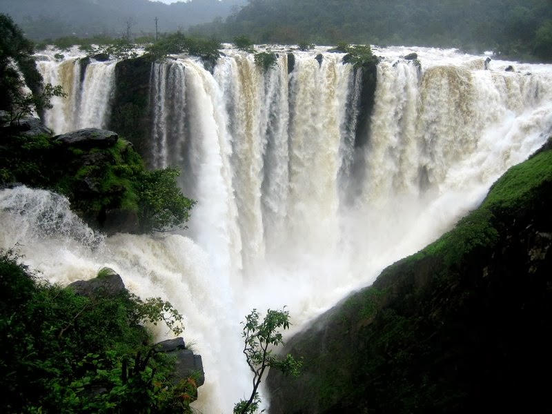
 The Sharavati, flowing over a very rocky bed about 250 yards
wide, here reaches a tremendous chasm, 290 m (960 ft) in depth, and the water
comes down in four distinct falls. The Raja Fall pours in one unbroken column
sheer to the depth of 830 ft (250 m). Half-way down it is encountered by the
Roarer, another fall, which precipitates itself into a vast cup and then rushes
violently downwards at an angle of forty-five degrees to meet the Raja. A third
fall, the Rocket, shoots downwards in a series of jets; while the fourth, the
Rani, moves quietly over the mountain side in a sheet of foam. The Tourism
Department has built steps from the view point till the bottom of the hill
where the waterfall can be seen at the opposite side. There are approximately
1500 steps built to reach the bottom of the hill.
The Sharavati, flowing over a very rocky bed about 250 yards
wide, here reaches a tremendous chasm, 290 m (960 ft) in depth, and the water
comes down in four distinct falls. The Raja Fall pours in one unbroken column
sheer to the depth of 830 ft (250 m). Half-way down it is encountered by the
Roarer, another fall, which precipitates itself into a vast cup and then rushes
violently downwards at an angle of forty-five degrees to meet the Raja. A third
fall, the Rocket, shoots downwards in a series of jets; while the fourth, the
Rani, moves quietly over the mountain side in a sheet of foam. The Tourism
Department has built steps from the view point till the bottom of the hill
where the waterfall can be seen at the opposite side. There are approximately
1500 steps built to reach the bottom of the hill.
Associated with the waterfall is the nearby Linganmakki Dam
across river Sharavathi. The power station has been operational since 1948, and
is of 120 MW capacity, one of the largest hydroelectric stations in India at
that time and a small source of electric power for Karnataka now. The power
station was previously named Krishna Rajendra hydro-electric project, after the
King of Mysore at that time. The name was later changed to Mahatma Gandhi
hydro-electric Project. It was served by Hirebhaskara dam until 1960. After
1960, due to the ideas of Sir M. Visvesvarayya, Linganmakki Dam is being used
for power generation.
Before the onset of monsoon season, when there is not much
water in the Linganmakki dam, the Jog Falls are only a pair of thin streams of
water trickling down the cliff, as the water collected in the dam is exclusively
for generation of electricity; during monsoons local rain-water is the source
of water to the falls.
Transport Connectivity:
- Nearest Railway Station (& distance to the location):
-
Talaguppa and SAGAR(SRF) : For Sagar 30 km
- Nearest Bus Station: Sagar
- Nearest Airport (& aerial distance to the location):
Domestic
- Hubli
Airport (HBX) : 130 km
-
Mangalore Airport(Formerly Bajpe Airport) (IXE) : 135 km
- Pune
Airport (PNQ) : 500 km
International
- Bengaluru International Airport
(BLR) : 340 km
No comments:
Post a Comment